
eNetra GIS Surveying Solution
Aerial capture to field assessment, in one suite.
A complete survey suite for urban local bodies, covering capture through to assessment. Drones capture the ward; the imagery processing software turns that capture into measured parcels and structures; the field app sends surveyors door to door to confirm what is present on the ground; and the admin dashboard and citizen application carry it through to assessment and collection. Every stage hands off to the next inside the same suite.
Walkthrough
The operations console in use.
Capabilities
What GIS Surveying does.
Planned photogrammetric capture
Flight lines, overlap and altitude are planned against the ward before the aircraft leaves the ground, and ground control points are placed so the output is survey-grade positioned.
Ground controlImagery converted to measured features
The processing software takes the raw capture through to an orthomosaic and surface model, then extracts the features a revenue department requires — parcel boundaries, building footprints, storeys, roof area — as measured vector features rather than a picture of them.
Measured featuresReviewer corrections retained as training data
Automated extraction proposes the features; a reviewer corrects them in the same tool. Corrections are retained as training and evaluation data, so accuracy improves on the client's own imagery instead of staying wherever it shipped.
Human reviewOffline field application
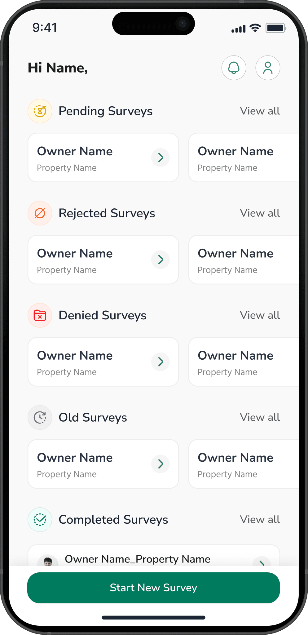
Wards rarely have reliable connectivity. Assignments, basemaps and forms cache on the device, area survey and door-to-door enumeration both continue offline, and everything syncs when the surveyor is back in range.
Offline-firstSurvey-to-demand administration
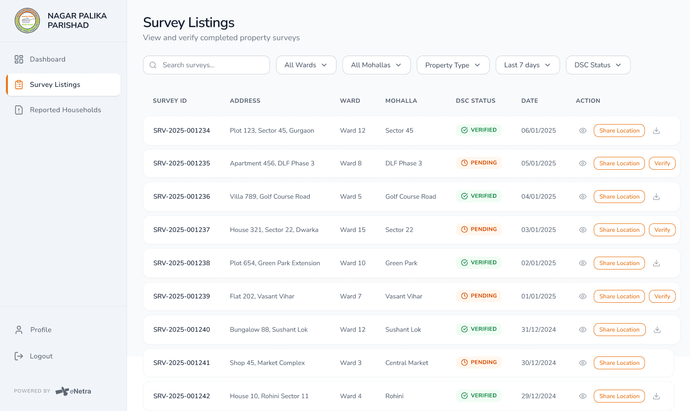
Supervisors see coverage by ward and enumerator, review submitted evidence, reconcile the surveyed position against existing records, and carry a property through assessment to a raised demand — without exporting to a spreadsheet in between.
Survey to demandStandard delivery formats
Deliverables are GeoTIFF, vector layers and point clouds that open in the GIS the client already runs. Data is delivered in formats that open in the client's existing GIS.
Open formatsHow it works
From acquisition to closure.
Plan
The ward, required accuracy and deliverables set the flight plan, control layout, survey schedule and assessment rules.
Capture
Drone flights cover the area from above while enumerators work door to door on the ground.
Process
Photogrammetry produces the orthomosaic, surface model and point cloud; parcels and structures are extracted as measured features.
Verify
A reviewer corrects the automated extraction, and field submissions are checked against it in the dashboard.
Assess
Confirmed properties carry through to assessment, demand and collection — and the citizen application shows the owner the basis for it.
System components
The components of a deployment.
Drone imaging
Planned aerial capture over the survey area.
- Mission planning against the ward or area of interest
- Ground control placement and survey-grade positioning
- Repeat captures aligned for change measurement
- Raw capture handed straight to the processing software
Drone imagery data processing software
The console that turns a flight into usable geography — orthomosaic, surface model, and the measured features on top of them.
- Photogrammetric processing to orthomosaic, DSM and point cloud
- Parcel boundary and building footprint extraction over an area you draw
- Automated detection corrected by a reviewer in the same view
- Areas, dimensions and counts measured off the processed surface
- Accuracy scored against the reviewer's own corrections
Field survey mobile app
Ground truth for what imagery cannot see — including door-to-door enumeration of every property in the ward.
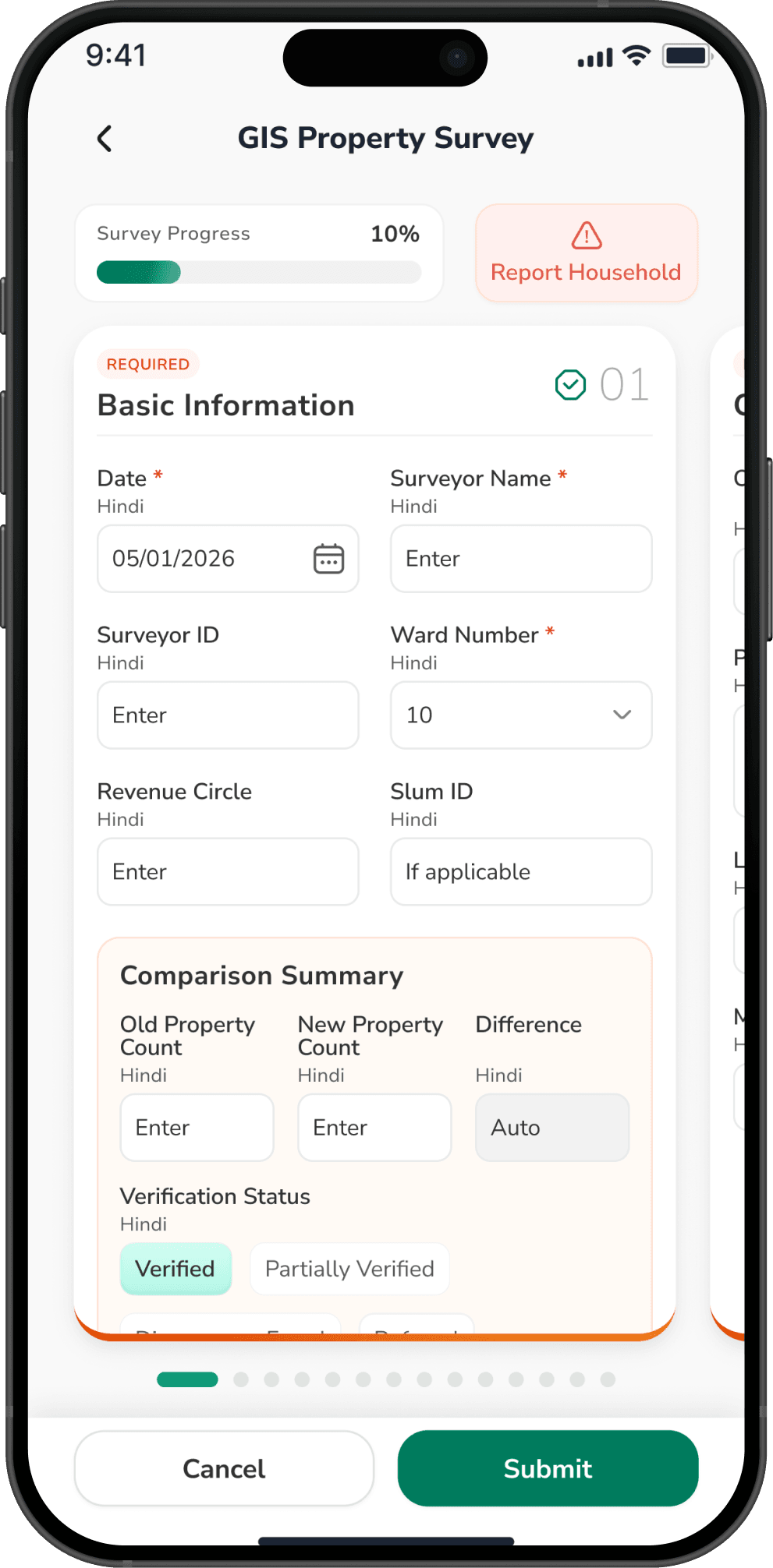
- House-to-house capture: property, household, occupancy and usage
- Records geo-tagged to the structure and joined to its parcel
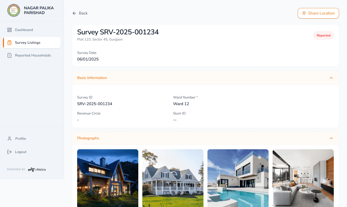
- Geo-tagged photographs of the structure and its frontage
- Offline through a full day's route, syncing when back in range
- Configurable survey schedules per project
Admin dashboard
The supervisor's view of the whole survey and the assessment that follows it.
- Assignment and coverage tracking by ward, zone and enumerator
- Review queue for submitted evidence, with approve or send-back
- Surveyed position reconciled against existing records
- Assessment, demand generation and collection status
- Exports and statutory reports in standard formats
Delivery and integration
How the work leaves the suite and lands in the systems the client already runs.
- GeoTIFF rasters, surface models and point clouds
- Measured parcel and footprint layers in standard vector formats
- Attribute tables carrying capture date and provenance
- Export or API hand-off into an existing GIS or revenue system
Property tax application
The citizen-facing application, where a property owner can view the assessment and its basis.
- Property record, measured area and assessment visible to the owner
- Objections and correction requests raised against a specific record
- Demand and payment status in one place
- Every change traceable back to the survey it came from
In use
The suite, on screen.
Field capture on the phone, and the processed survey in the console — the same property, seen from both ends of the job.
What you get
What a deployment delivers.
- Orthomosaic (GeoTIFF), digital surface model and point cloud
- Measured parcel and building-footprint layers
- House-to-house records joined to the property they describe
- Reconciled property register with assessment status
- Extraction accuracy report against reviewed ground truth
Intended users
| Aerial capture | Photogrammetric drone survey with ground control |
|---|---|
| Processing outputs | Orthomosaic, DSM, point cloud, measured vector features |
| Feature extraction | Automated detection with human review and correction |
| Field client | Android and iOS — area survey and house-to-house enumeration, offline-first |
| Administration | Web dashboard: assignment, review, assessment, demand, collection |
| Citizen client | Property record, objection and payment status |
| Delivery formats | GeoTIFF, standard vector layers, point cloud |
| Engagement | Per project or as a managed capability |
Request a demonstration over your area of interest.
Provide the boundary of your jurisdiction and we will run GIS Surveying against current imagery of that area.
Other systems